Washington's snowpack is suffering this winter. It's not going to get much better
State climatologist Nick Bond was expecting a lower snowpack this year — but not this low.
Washington state has been on the warm side, with the exception of a deadly cold snap in mid-January. In fact, Seattle recently experienced its warmest January week on record after also going through the city's warmest December on record.
The warmth, and subsequent snowpack struggles, haven't been entirely unexpected. Washington is in the middle of an El Niño winter, which brings warmer and drier conditions to the region.
But it's also part of a global trend: The 10 warmest years since 1850 have all occurred in the past decade, according to NOAA. And climate scientists have already said there is a 99% chance that 2024 will rank among the top five warmest years.
RELATED: Seattle records its warmest December. What does that mean for mountain snowpack?
Higher temperatures may mean more precipitation falls as rain instead of snow, thus affecting the snowpack.
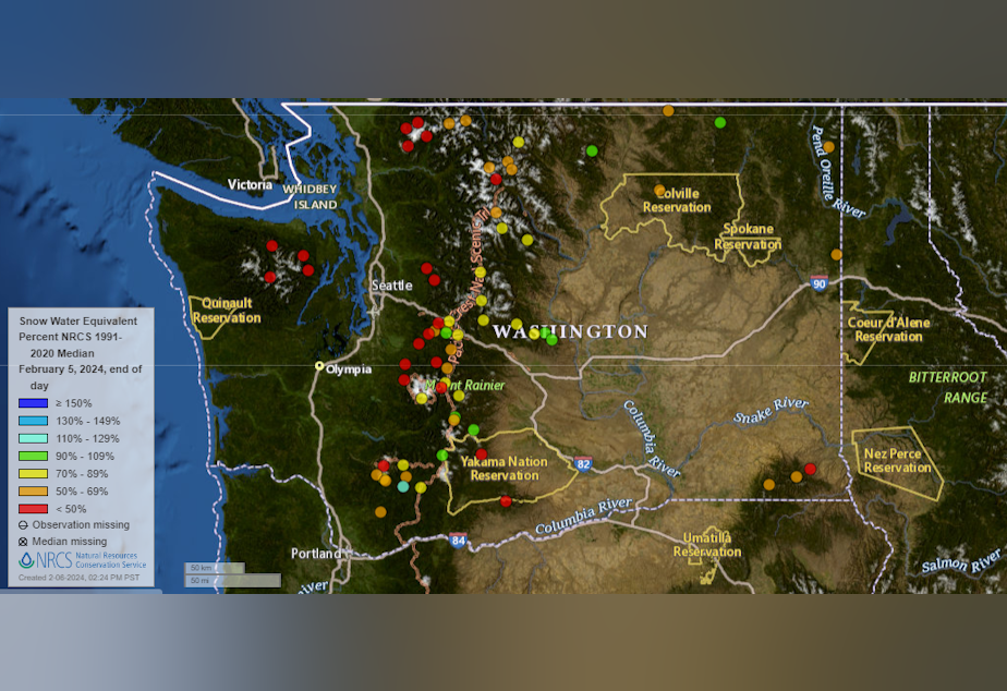
Bond said he expected the snowpack to be low this winter, but the extent to which it is "is a bit alarming," especially in the Olympic Mountains, where it's at just about 29% of normal. Other parts of the state have been better off, he said, like the central Cascades, where the snowpack is at about 60-70% of normal, he said.
A low snowpack in the winter translates to less water supplies for agriculture in the summer and a drier landscape that could fuel a nastier wildfire season.
"By no means are [snowpack levels] historically low, but they are getting low enough for concern," Bond said. "And the the problem is that at the end of these El Niño winters, it tends to be on the warm, dry side. So, it'd be unlikely — not impossible, but unlikely — for us to really get a healthy snowpack at this point."
RELATED: Seattle just had the warmest week in January on record
Bond said he's hoping for a cool, wet spring to delay the start of summer, when the snowpack will melt. But as we continue to grapple with a warming climate, he said years like this will get more common.
"The idea that we're going to be going into summer with lower snowpacks is something we have to get used to," he said. "And so, you know, I'm not sure this really qualifies as a wake-up call, but maybe there's some lessons to be gained."
Share your thoughts on this story
-
Katie Campbell

Online Editor/Reporter
Katie joined KUOW's online team as an editor and reporter in 2024, after serving three years as senior producer of the local Morning Edition program. She has covered a variety of local topics, including the Seattle City Council, elections, and breaking news. She also brings readers some levity with a weekly news quiz.
More stories from Katie Campbell »


