Rising Northwest waters bring tough choice: fight or flight
Fight or flight.
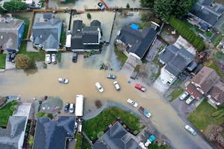
That’s the dilemma people living at water’s edge face as a hotter climate pushes Puget Sound and nearby rivers higher.
Fleeing to higher, drier ground can be wrenching, while digging in and trying to hold the waters back can be costly, if not dangerous.
Neighbors of the Skagit and Stillaguamish Rivers, just north of Seattle, have been tackling this 21st century dilemma for years — though in opposite ways.

Anacortes’ ark
On the inside of a big curve in the Skagit River, a cluster of buildings sits in the shadow of a tall levee. The earthen levee keeps the river away from the city of Anacortes’ water treatment plant — usually.
“This area could essentially be inundated with water,” said Jeff Marrs, who runs the plant that 56,000 customers in Anacortes, LaConner, Oak Harbor and the Swinomish Reservation depend on for their drinking water.
When the Skagit runs too high, it can top the levee and flood the treatment plant, which sits 20 feet below the top of the dike.
“Any overtopping from the dikes would have resulted in immediate contamination of our water supply,” Marrs said.
As the global climate keeps heating up, Washington state is expected to get less snow and more rain, which runs quickly off the land. Floods on the Skagit are expected to get 23 percent bigger in the next 20 years and 49 percent bigger by the 2080s, according to the Skagit Climate Science Consortium.
And as the headwaters in the North Cascades get less snowy and more muddy, the river is expected to carry 4 times more sediment downstream than it does today.
The extra sediment would greatly complicate the task of providing clean drinking water from what is already Puget Sound’s siltiest river.
Unlike many politicians and businesses, Anacortes officials recognized the unpleasant reality of climate change a decade ago. So when their old treatment plant needed to be replaced, they designed the new one to be flood-proof and capable of removing much more sediment.
Anacortes public works director Fred Buckenmeyer said he had an “aha moment” after learning how the Skagit basin would be altered by a changing climate.
“I'm just a public works guy. I love to build stuff, but I only like to build it just the one time," he said.
The $60 million plant opened in 2013. Buckenmeyer said he didn't have a precise estimate, but he guessed that the climate-driven features added $5 million to the total cost.
Now, the plant’s operations center and mission-critical electronics sit on the top floor, out of the reach of flood waters.
The whole plant is built within a waterproof membrane, so it can keep providing drinking water no matter what a hotter climate might bring.
“We could have it flooding around us, and our infrastructure would remain intact, and we could still run the facility with floodwaters around us,” Marrs said.
Marrs said the watertight plant is essentially built like a ship.
“But it's anchored at the bottom with a bunch of pilings to keep it from drifting,” he said. “It should last the city a very long time.”
Sledgehammer science
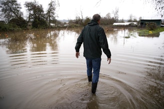
While the treatment plant on the Skagit is standing its ground, that approach won’t work everywhere.
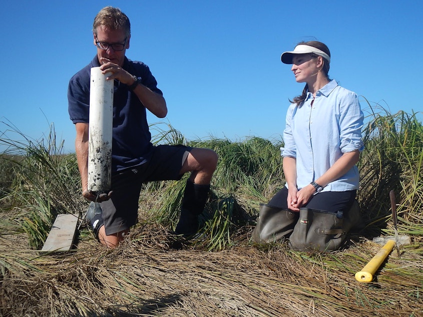
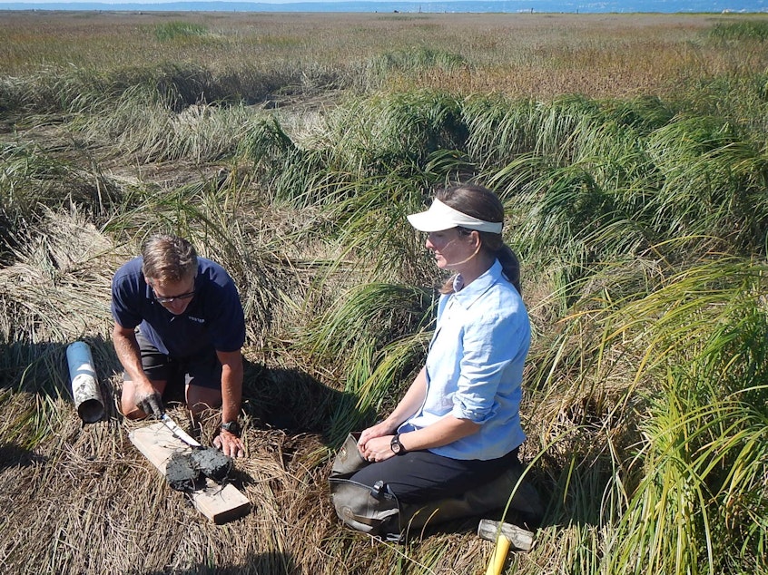
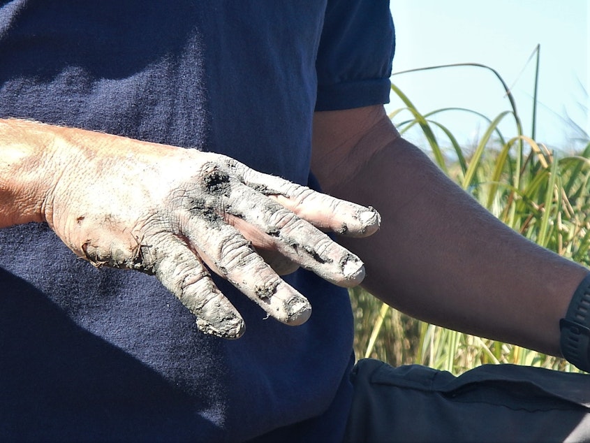
One river to the south, Katrina Poppe and John Rybczyk sledge-hammered a white, meter-long tube of plastic into the mud.
Rybczyk sported mud boots and shorts; Poppe, hip waders. Both were surrounded by sedges, rushes and other marsh plants near the mouth of the Stillaguamish River, just south of Stanwood.
The Western Washington University ecologists have been studying a soggy 150-acre plot with low-tech and high-tech tools.
“We pound it into the sediment, and then you extract it so you can have up to a meter of sediment,” Poppe said of their brute-force method of extracting data from mud. “It shows you the different layers.”
Those layers of sediment tell the story of evolution from marsh to farm to marsh again.
The farm, diked off from the tides in the 1950s, had salty soil that best supported salt-tolerant crops, like bentgrass, used for putting greens on golf courses.
When the farmer who owned this land died, his estate faced the choice: keep pushing the waters back or retreat to higher ground. The farm flooded regularly, even though it was protected by a dike.
“When this was ag[riculture] land, it was drained, and it started subsiding, so this was becoming lower and lower and harder and harder to pump out. And eventually it wasn't feasible,” Rybczyk said.
In 2001, the estate decided to sell the salty farm to The Nature Conservancy, which had very different plans for it.
“We removed the seafront dike along the edge of what was agricultural land and moved it back,” Molly Bogeberg with the conservancy said from the back of a pickup truck rumbling along the new dike.
On one side, rows of crops, on the other, a 7-year-old salt marsh.
Even though 150 acres of farmland were lost with the breaching of the dike in 2012, Bogeberg said what remains is better protected from flooding. The new marsh in front of the new dike absorbs wave energy coming off Puget Sound, and the new dike has gates in it that let the farmland drain quickly, should it flood.
“There needs to be balance, right?” Bogeberg said. “It's important habitat for fish, but it's also important farming land for people.”
The Nature Conservancy’s main goal was to create more salt marsh for threatened young Chinook salmon to feed and hide in before heading to sea.
“Estuaries are sort of a bottleneck for that species,” Bogeberg said.
But Rybczyk and Poppe’s sediment studies have found other benefits, too.
Racing the sea -- and winning
With sea level rise, whatever’s on a low-lying shoreline could be swallowed by the sea, whether it’s a building, a farm, or a marsh.
But the researchers found that this new marsh, full of fast-growing plants, has been more than holding its own against the rising tides.
The marshy area outside the dike is already at a perceptibly higher elevation than the still-subsiding farmland inside the dike.
Rybczyk explained that the marsh plants slow down silty water as it flows past.
“Those sediments get captured and build up the soil, so as the sea level rises, the marsh can rise," he said. "It can keep pace with the rate of sea level rise, and you always have the coastal marsh.”
The marsh has risen nearly 8 inches since the researchers started measuring its elevation six years ago: 10 times the pace of sea level rise and three times the pace of older marshes in the area.
“It's building up so quickly,” Poppe said.
Since this marsh was restored, others have followed along the Stillaguamish delta.
The Stillaguamish Tribe restored 88 acres of marsh in 2017, and the Washington Department of Fish and Wildlife connected 250 acres of nearby coastal land to the tides in October.
Rybczyk expects marshes all around Puget Sound can keep pace with sea level rise, too, since rivers around here carry so much sediment from surrounding mountain ranges down to the sea.
Such resilience in the face of climate change would be good news for the sound’s threatened Chinook salmon and the endangered orcas that prey on them.
On the Stillaguamish, the Nature Conservancy’s young marsh is even helping, in a small way, to fend off the climate change that is pushing seas around the world higher.
Rybczyk pointed to the cylinder of gunmetal-gray sediment he and Poppe had pulled up from the marsh and extracted from the plastic tube.
“You can see it right there. There it is,” he said: The dense marsh mud was full of carbon that plants had sucked out of the air.
“This is carbon, through photosynthesis trapped by the plants, locked here now, locked and stored, never to warm the earth again,” he said.
The gray color showed that oxygen wasn’t penetrating the muck enough to cause iron in the soil to rust—and that the carbon sequestered underground won’t oxidize and escape back to the air, unlike much of the carbon in farmland or forest soils.
Their research shows that the young marsh is trapping twice as much carbon as nearby marshes that were never diked.
Rybczyk said salt water, by deterring microbes that could turn the plant material in the mud into powerful heat-trapping methane gas, helps make tidal marshes some of the most effective ecosystems for helping cool an overheated planet.
While planting trees is a popular way to remove carbon from the atmosphere, planting a marsh can remove even more.
-
John Ryan

Environment Reporter
John Ryan joined KUOW as its first full-time investigative reporter in 2009 and became its environment reporter in 2018. He focuses on climate change, energy, and the ecosystems of the Puget Sound region.
More stories from John Ryan »