3.8 million people are now in Washington's drought zone. And it's only mid-May
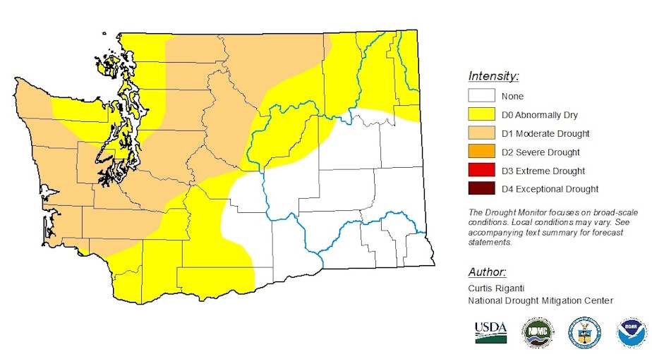
Dry conditions in Western Washington have intensified over the past week, with 3.8 million people living in areas now classified as in drought.
The weekly map from the National Drought Mitigation Center, released Thursday, shows abnormally dry conditions or moderate drought cover the same area in Washington as last week -- about 70 percent of the state.
But most of King, Pierce and Snohomish counties are now in moderate drought.
Washington state is "one of the few areas in the country experiencing drought,” meteorologist Brad Rippey, co-author of U.S. Drought Monitor, said in an interview.
“If you look at the net period going back to the beginning of the water year [in October], much of Western and Central Washington has come up short.”
Rippey said Washington has a below-average snowpack, especially in the northern Cascades.
Sponsored
"This may be a very unique year in the sense that we’re looking at our greatest likelihood for hot, dry conditions in the more coastal and west of the Cascades areas,” Rippey said, not east of the Cascades.
The National Weather Service Climate Prediction Center summer forecast, released Thursday, shows a 50 percent probability of higher temperatures in Western Washington. In the eastern part of the state, that probability was lower.
Rippey said a lot of Washington has not recovered from 2018's hot, dry summer. And he said drought conditions started later in 2018, when the Seattle area saw days of smoky conditions from wildfires to the north and east.
But conditions aren't as bad as in 2015, when at this point in the year, half of the state was in moderate to severe drought.
Still, in a sign that resource managers are concerned about the coming months, the National Park Service has closed campsites along Ross Lake because of low water levels.
The Park Service said levels on the reservoir were predicted to be significantly lower than normal this summer because of a "lack of rainfall, a decline in snow pack, and the protection of chum salmon redds resulting in a drawdown by Seattle City Light."
(Here's City Light's assessment of water supplies for its hydroelectric dams.)
Sponsored
Denise M. Shultz, chief of visitor services for the North Cascades National Park Service Complex, said in an email that the lake level for late August was predicted to be 1,580 to 1,591 feet. The lake is considered full at 1,601 feet.
Shultz said the lake was also low in 2001 at 1,590 feet. She said visitors to the Ross Lake National Recreation Area have more than doubled since then.
In addition to campsites accessed by boat on Ross Lake, the Park Service closed most of the exposed lakebed and boat ramps at Hozomeen.
The Park Service left open that areas could be reopened if there's sufficient rainfall to raise the lake.
-
Casey Martin

Reporter
Casey Martin is a reporter who covers everything from political protests to electric scooters. He is almost always out in the field where the news happens. Casey has reported on extremism, homelessness, politics, and Seattle’s nightlife. He got his start in radio at KBCS Community Radio in Bellevue and is a proud graduate of the Transom Traveling Workshop on Catalina Island. Casey joined KUOW in 2015.
More stories from Casey Martin »