Seattle just had the warmest week in January on record

Seattle's average temperature in the past week was 53.8 degrees. According to the National Weather Service, that was the warmest seven-day period between Jan. 1 and Feb. 1 on record since 1984.
This after Seattle experienced its warmest December on record. Statewide, it was the third warmest December on record, according to the Office of the Washington State Climatologist. Plus, 2023 was the planet’s warmest year on record, according to an analysis by scientists from NOAA’s National Centers for Environmental Information.
“After seeing the 2023 climate analysis, I have to pause and say that the findings are astounding,” said NOAA Chief Scientist Dr. Sarah Kapnick. “Not only was 2023 the warmest year in NOAA’s 174-year climate record — it was the warmest by far. A warming planet means we need to be prepared for the impacts of climate change that are happening here and now, like extreme weather events that become both more frequent and severe.”
"We will continue to see records broken and extreme events grow until emissions go to zero,” Kapnick said.
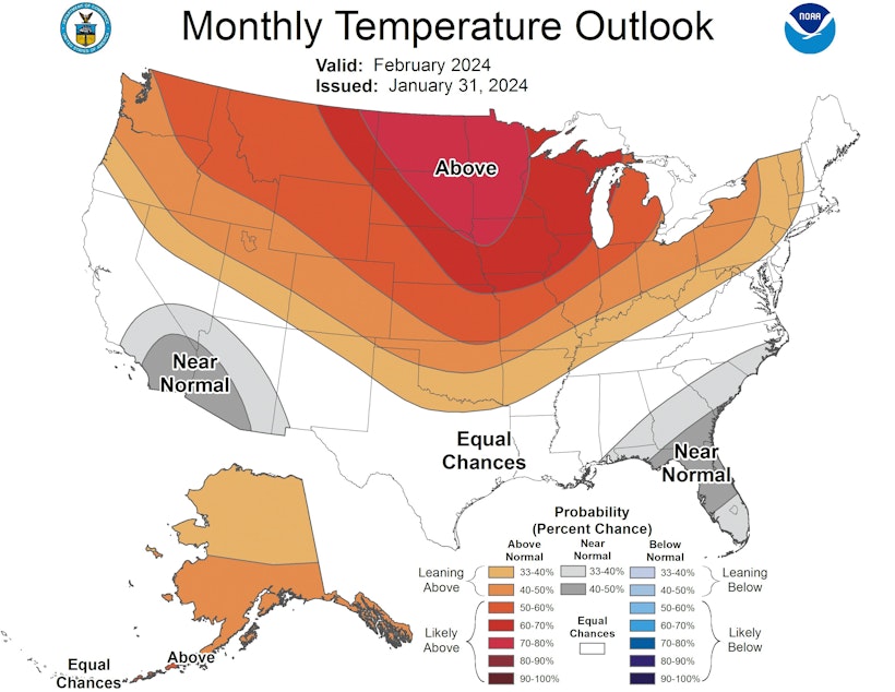
Seattle may see more winter records broken this year. The NWS Climate Prediction Center is forecasting spring-like conditions over the next month.
Sponsored
Part of what is driving above-average temperatures is the fact that we're in the middle of an El Niño winter. El Niño conditions are typically warmer and drier in Washington.
Deputy state climatologist Karin Bumbaco explained the conditions Washington saw in January during a meeting of the Water Supply Availability Committee. Those conditions included both severe cold and the unprecedented warm spell just this week.
Bumbaco attributed the severe, and deadly, cold snap in mid-January to a rare "one-two punch" of conditions at the time. To summarize her very technical explanation, the cold snap resulted from a temporary weakening of El Niño conditions and changes in the polar vortex. In other words, the event was not typical of an El Niño.
And here's an interesting side note: The cold snap was more extreme than our recent warm spell in terms of variance from the normal. Temperatures during the cold snap fell up to 24 degrees below normal, according to the National Weather Service. Temperatures were up to 13 degrees above normal during the warm spell.
Sponsored
RELATED: Homeless people in Seattle endure brutal winter cold, 'one night at a time'
Even with that cold snap, Bumbaco said temperatures have been above normal so far this year, and precipitation has been below normal. Models show those conditions are likely to persist through April.
Both El Niño and La Niña are normal weather patterns — they're the result of water temperatures off the coast of South America near the equator. These patterns occur naturally.
But human pollution from fossil fuel burning and other sources has also been driving temperatures inexorably upward in the Seattle area and around the world. Average annual temperature in the Pacific Northwest has increased 1.3 degrees Fahrenheit over the past century, with the frost-free season lengthening by 35 days, according to the University of Washington's Climate Impacts Group.
Sponsored
Globally, there is a one-in-three chance that 2024 will be warmer than 2023, according to NOAA.
The 10 warmest years since 1850 have all occurred in the past decade, according to NOAA. And climate scientists have already said there is a 99% chance that 2024 will rank among the top five warmest years.
If you want to get more specific, winter is the fastest-warming season for most of the U.S., according to the nonprofit Climate Central. The effects of warmer winters could impact everything from Seattleites' beloved winter sports to the very things humans depend on, like crops and water supplies.
KUOW's John Ryan contributed reporting to this story.


