Rocketing boulders, dwindling streams: signs of WA's shriveling glaciers
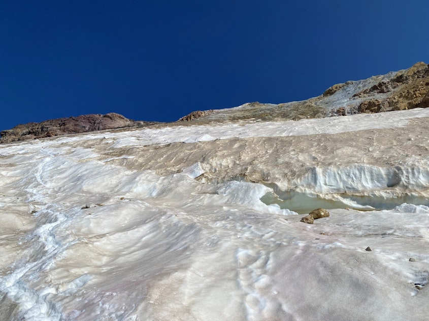
Zack McGill was guiding a group of climbers down from the icy summit of Washington’s Mount Baker when he saw something few have seen: torso-sized boulders rocketing down the mountain at about 40 miles an hour.
“They were gaining enough speed on the bare ice to bounce high in the air and clear the large crevasses at the base of the Roman Wall and continue down the Deming [Glacier],” said McGill, a mountain guide with Cascade Mountain Ascents in Bellingham, by email.
McGill said the rock projectiles fell about 2,000 vertical feet before disappearing in crevasses or slowing to a stop on the surface of the ice.
As a warming climate shrinks the rivers of ice atop Mount Baker and other mountains around the world, it’s exposing rock faces and cliffs that haven’t seen daylight for millennia.
“The overhead hazard, from rockfall from the melting out of the ice completely to dirt on the upper mountain is INSANE,” McGill said. "It's been getting worse every year I've been here, but this year is just crazy.”
Sponsored
Cascade Mountain Ascents canceled all remaining climbs on that side of the mountain as a result of McGill’s scary experience in late July.
“No summit is worth your life,” McGill said. “I’ve summited Mount Baker 76 times from all sorts of ways and don’t feel the need to push it anymore late in the season.”
The changes are noticeable from the lowlands. Each summer since a record-smashing heat dome in 2021, Mount Baker has been living up to its Nooksack name Kweq’ Smánit (white mountain) less and less.
“It seems that Baker gets more and more brown every year,” Bellingham geologist and mountain biker Liza Kimberly said by email.
Sponsored
Mountain bikers at the popular Galbraith Mountain trails on the outskirts of Bellingham have been noticing the view of the 10,781-foot volcano on the horizon has changed.
“I feel like someone makes a comment about how brown the mountain is nearly every time I'm there,” Kimberly said. “This year, it almost looks like the majority of the mountain is brown dirt and not glacier ice.
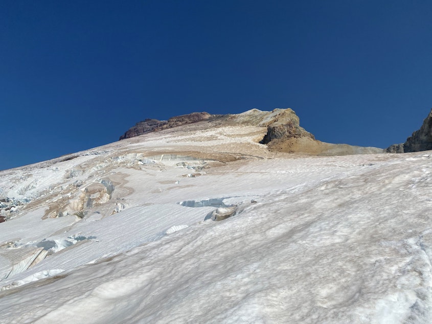
Nichols College glaciologist Mauri Pelto recently completed his 40th annual survey of glaciers on Mount Baker and other Cascade peaks.
He said Mount Baker’s Easton Glacier retreated faster this year — losing an area of ice the size of a football field in 12 months — than any Cascades glacier he’s studied in the past 40 years.
“It's changed so fast that you really can't recognize the area,” Pelto said. “There's two new waterfalls. And you're looking up at the glacier, ‘What the heck? That's where I stood on ice last year, and now there's just a waterfall streaming down rock.’”
Sponsored
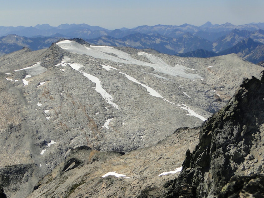
In August, Pelto and his team also surveyed the cluster of glaciers around King County’s highest peak, Mount Hinman, and neighboring Mount Daniel.
“What we found was the worst year of glacier melt that we've seen [in] any of the 40 years,” Pelto said.
The complex of glaciers at the roof of King County has collapsed.
By the end of the summer, King County could be down to just one glacier.
Sponsored
Until recently, the pair of peaks, roughly midway between Stevens and Snoqualmie passes along the spine of the Cascades, had five glaciers: three in King County and two in neighboring Kittitas County.
The biggest of those (Hinman) melted away by last summer, and the smallest (Iceworm) died this summer.
READ: RIP Washington’s Hinman Glacier, gone after thousands of years
Pelto expects the Foss Glacier, one of King County’s two remaining glaciers, will disappear next month or by next summer at the latest.
The loss of the Foss would make the Lynch Glacier King County’s sole river of ice.
Some remnant ice patches may survive elsewhere, but glaciologists say a glacier stops being a glacier when it is no longer large and thick enough to generate its own movement and flow across the landscape.
Sponsored
Glaciers have naturally advanced and retreated for millennia, with many shrinking after the Little Ice Age ended in the 19th century. For several decades during the mid-20th century, many Northwest glaciers grew, but most have been shrinking since the 1980s, with their meltoff accelerating as the human-altered climate has heated up.
“We just see a dramatic acceleration in the rate of loss,” Pelto said. “So it's not just a continuation from the Little Ice Age.”
The impacts reach farther than rolling boulders.
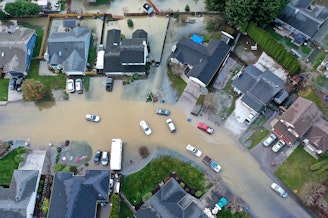
With less mountain ice to provide meltwater in the dog days of summer, mountain streams and the rivers they feed run lower and warmer each summer. Fish and farmers both pay the price.
Cle Elum Lake, the reservoir that meltwater from Mount Hinman and adjacent areas of the central Cascades flow into, was at 10% of its capacity on Aug. 30, according to the U.S. Bureau of Reclamation.
In King County, the glacier-fed Skykomish River has flowed at less than 10% of its annual average and exceeded federal water-temperature standards since Aug. 13, according to Pelto.
Drought, heat, and water withdrawals also influence river flows and temperatures. Large glaciers can moderate those impacts.
Pelto said his summer field work on Washington’s rivers of ice can take on a surreal feel, as he stands on newly exposed earth and watches mushroom-shaped pyrocumulus clouds erupt above wildfires nearly every day.
He may eliminate some locations from his monitoring agenda as those glaciers disappear, but he said he’s determined to keep at it until he’s documented 50 years in a row, a decade from now.
-
John Ryan

Environment Reporter
John Ryan joined KUOW as its first full-time investigative reporter in 2009 and became its environment reporter in 2018. He focuses on climate change, energy, and the ecosystems of the Puget Sound region.
More stories from John Ryan »