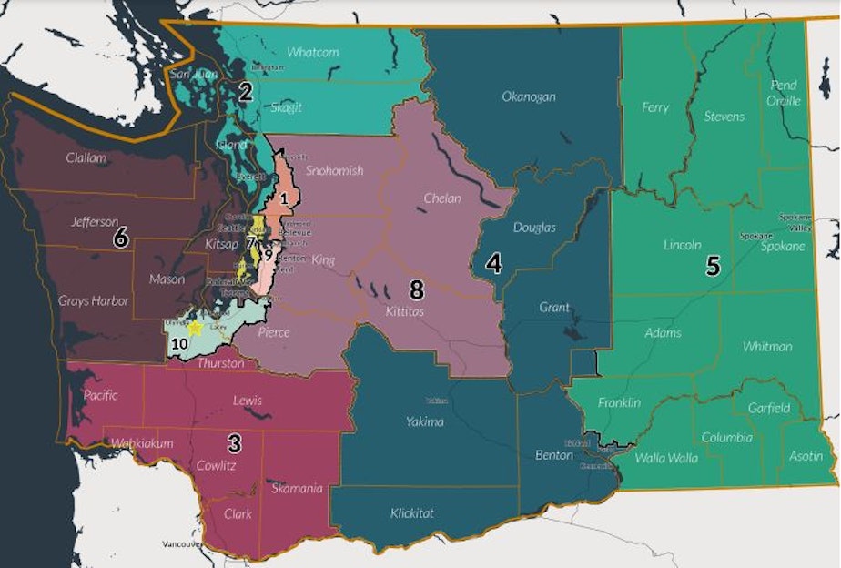
Despite missing deadline, commission did draw a map for Washington's congressional districts

Washington state's bipartisan redistricting commission released new congressional and legislative maps Tuesday night — a day after its deadline. The mapping job now goes to the state's Supreme Court.
At a Thursday press conference, its members urged the court to use the political maps they created, despite the missed deadline.
The proposed map from the commission provides insight into how the state's congressional districts could appear moving forward, should the court agree. The court has until April 30, 2022 to finish the job.
RELATED: New voting maps to be drawn by state Supreme Court, after historic fail by commission
Perhaps the biggest change the commission came up with is the borders for the 8th Congressional District. It is currently represented by Democratic Congressmember Kim Schrier who took 51.7% of the vote in 2020 and 52.4% in 2018. Before Schrier, the district was steadily represented by Republicans — most recently Republican Dave Reichert, from 2005 to 2019.
Washington's 8th Congressional District currently includes much of Chelan, Kittitas, Pierce, and King counties (without covering the larger populated cities of Bellevue and Seattle). It includes the cities of Ellensburg, Wenatchee, Leavenworth, and Issaquah.
Under the proposed new boundaries, the 8th Congressional District would stretch further north, taking on more of north King County and carving into rural Snohomish County. It would then includes cities like Sultan and Skykomish. This area is currently represented by Democrat Suzan DelBene. And Snohomish County favored Biden by 58.5% in the 2020 presidential election.
Washington's other congressional districts lose and gain small areas here and there, but largely stay the same.
However, there are significant changes for the Puget Sound region around Seattle.
- What was once the 1st Congressional District that covered much of inner King, Snohomish, Skagit and Whatcom counties, will be shrunk down to cover, roughly, north Bellevue through the Marysville area.
- The 2nd Congressional District, which formerly covered much of Puget Sound's coastal communities and islands, would extend inland covering Skagit and Whatcom counties (formerly part of the 1st District).
Paul Graves, a redistricting commissioner, is a former Republican state representative from Fall City. He hopes the Supreme Court will use the maps the commission came up with.
"We worked very, very hard, and ultimately late in the night reached a framework that we all voted for," he said.
Graves said he believes there are ways to avoid the deadline problem in future by setting the deadline five days before maps are actually due.
Brady Walkinshaw is one of the two Democratic appointees to the bipartisan commission. At a Thursday press conference, he agreed with his Republican counterpart.
“I would definitely urge the strong consideration of these maps to the Supreme Court,” Walkinshaw said Thursday.
But Walkinshaw also raised a doubt about how the maps addressed voting rights for Latinos.
“My one area that I left with reservations on has been around voting in the Yakima Valley,” he said. “I think there are real questions about the voting rights act.”
Separately the UCLA Voting Rights Project issued an analysis. It asked the court to address what it calls racially polarized voting patterns in the Yakima Valley.


