El Niño is 'on the wane.' What is in the forecast for Washington?
Washington's mountains have been watched closely this winter as snowpack has struggled to build in many parts of the state. But the season is already changing, and forecasters are looking ahead to the summer and even next winter.
“We're not going to have the same kind of weather that we had at the end of February into March, in which there was some really good growth for our snowpack … but it's going to be warmer," Washington state Climatologist Nick Bond told KUOW's Angela King. "I don't think there's much of a chance of a full recovery of the snowpack [for the rest of 2024].”
RELATED: U.S. hydropower drops to 20-year low as Northwest snowpack shrinks
The recent snow that hit Washington's mountains has been beneficial, but Bond says the region's snowpack is "not out of the woods yet."
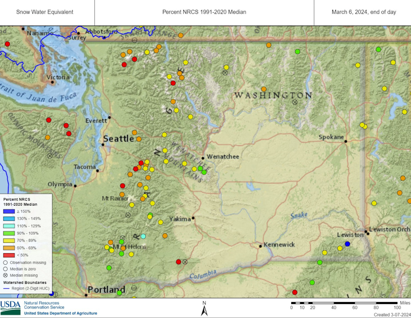
Washington state's snowpack is roughly at 70% of normal, at this point. That depends on where you look around the state, however. The Olympic Mountains, for example, are at about half the normal level of snowpack. Part of the blame belongs to the El Niño climate pattern we're currently in — when conditions are generally warmer and drier than normal, especially in late winter.
Sponsored
“For what it's worth, this El Niño is on the wane and it looks like by the end of spring, we're going to be in neutral conditions in the tropical Pacific," Bond said, adding that looking further into the future, it's quite possible that we'll have La Niña conditions, yet again.
We just had three La Niñas in a row, which is quite rare.
"During La Niña winters, especially latter part, it tends to be on the cool side and sometimes wetter, leading to better snowpacks. If we can get through the summer without too many problems, maybe we'll get a reprieve.”
Snow in the mountains is essentially Washington's summer water supply — it melts and sends water downstream to communities throughout the state. At this point, it's expected that parts of the state will be in good shape over the summer, when it comes to water supply. The major cities should be OK. In other areas, irrigation and water rights could be an issue, Bond says, and many streams may be too low for comfort for trout and salmon.
Sponsored
Big picture: The worst year on record for Washington's snowpack was the winter of 2014-15. Bond says 2024 is in better shape, as long as the spring isn't too warm and dry.
RELATED: RIP Washington’s Hinman Glacier, gone after thousands of years
As of March 2024, the National Weather Service's long term seasonal temperature and precipitation outlooks for Western Washington predict temperatures that "lean above" normal through October, while precipitation is expected to lean below normal through July, and could go either way after that.
-
Dyer Oxley

Online Editor/Producer
Dyer Oxley joined KUOW as an Online Editor/Producer in 2020, handling day-to-day upkeep of the station’s website while providing editorial oversight. He also helms KUOW’s Today So Far newsletter, an insightful daily roundup of what KUOW is reporting ... so far.
More stories from Dyer Oxley » -
Natalie Akane Newcomb

Announcer / Producer
Natalie is a recent graduate from Washington State University. She started writing radio features at her high school’s radio station 889 TheBridge and soon thereafter participated in RadioActive's summer 2016 workshop.
More stories from Natalie Akane Newcomb » -
KUOW Staff More stories from KUOW Staff »