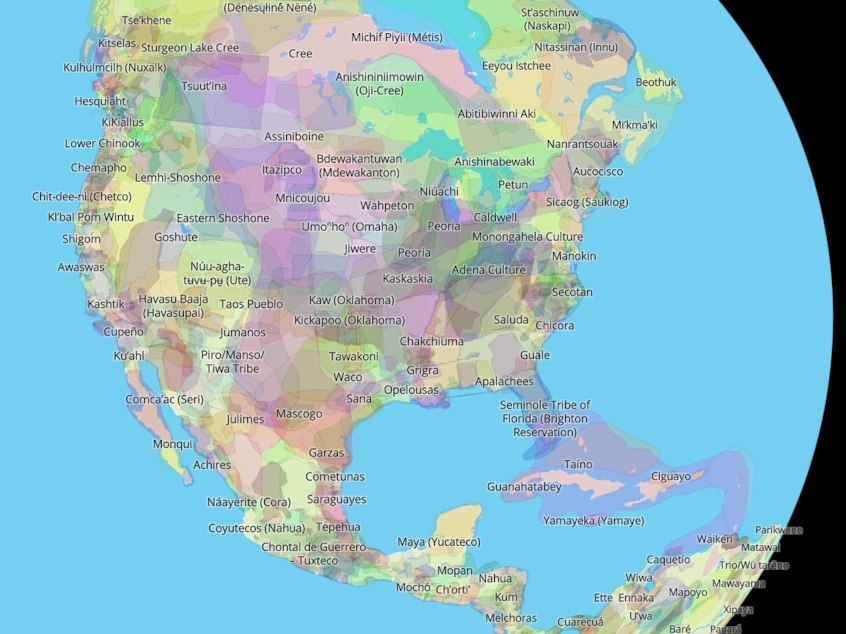
Which Indigenous lands are you on? This map will show you

President Biden became the first president to officially recognize Indigenous Peoples' Day in 2021, and did so again this year. It falls on the same day as Columbus Day, which was first founded as a way to acknowledge the mistreatment of Italian Americans.
The new holiday is a time of reflection, recognition and celebration of the role Native people have played in U.S. history, as NPR has reported. One way to mark the day — and to learn about Indigenous history year-round — is to learn which Native lands you live on.
Acknowledging an area's original inhabitants and stewards is a valuable process, albeit a complex one, as the National Museum of the American Indian explains. The museum suggests reaching out to local Indigenous communities for guidance involving formal land acknowledgements, which can be offered at the start of public and private gatherings.
"Many places in the Americas have been home to different Native Nations over time, and many Indigenous people no longer live on lands to which they have ancestral ties," the museum says. "Even so, Native Nations, communities, families, and individuals today sustain their sense of belonging to ancestral homelands and protect these connections through Indigenous languages, oral traditions, ceremonies, and other forms of cultural expression."
This map's creators want it to convey more than borders
Sponsored
Native Land Digital, an Indigenous-led nonprofit based in Canada, is working to facilitate such conversations and document this history including by putting together a searchable map of Native territories, languages and treaties.
Users can click on labels across the Americas and around other parts of the globe — or type a specific city, state or zip code into the search box — to see which Indigenous tribes lived where. You can zoom in or out, as well as choose to apply "settler labels" to see how the map corresponds with contemporary state lines. Clicking on the name of each nation brings up links for related reading.
The map is available on the organization's website and on iOS and Android mobile apps. Native Land Digital also publishes resources to go with the map, including a teacher's guide and a territory acknowledgement generator.
The nonprofit says it aims to improve the relationship of people — both Indigenous and non-Indigenous — with the history and sacredness of the land around them. That involves "acknowledging and righting the wrongs of history."
"We hope to inspire people to gain a better understanding of themselves, their ancestors, and the world they live in, so that we can all move forward into a better future," it says.
Sponsored
The map itself is "more than a flat picture," as the nonprofit explains, pointing out that land is sacred to everyone regardless of how consciously they appreciate it.
"In reality, we know that the land is not something to be exploited and 'owned,' but something to be honoured and treasured," it says. "However, because of the complexities of history, the kind of mapping we undertake is an important exercise, insofar as it brings an awareness of the real lived history of Indigenous peoples and nations in a long era of colonialism."
Mapping tribal lands comes with challenges
The nonprofit acknowledges the many logistical and ethical questions that come with mapping Indigenous territories. Those range from defining "Indigenous" across time and space to engaging with those communities so they can "represent themselves and their histories on their own terms."
Native Land Digital aims to use at least two valid sources (including oral history, written documents or "maps sketched by people deemed to be reasonable authorities") when updating the map, and says in cases of conflicting maps it generally errs on the side of being "more expansive."
Sponsored
It cautions that the map does not represent definitive or legal boundaries of any Indigenous nations, and is a work in progress with many community contributions.
"We ... encourage people to treat these maps as a starting point and to do their own research in engaging with communities and history themselves," the group says.
The map has already made an impact
Native-Land.ca was created in 2015, and the organization was incorporated as a nonprofit in 2018. The group says it's found over the years that its maps have made a direct impact on peoples' lives.
That's been true of Indigenous people, who have been glad to see their nation mapped or surprised to see how large their traditional territories look on a standard Western map, as well as non-Indigenous people who may be "for the first time, encountering the depth, breadth and complexity of Indigenous history on the land."
Sponsored
"Some people may be made uncomfortable by the new information and history the map brings forth," the nonprofit adds. "But we are secure in knowing that truth is the best teacher, and we hope to provide the best information we can to help people come to their own conclusions about themselves and their place in the modern world." [Copyright 2022 NPR]


